
By Dan Buckler, Urban Forestry Assessment Specialist, DNR
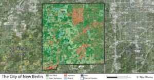
The Urban Forestry program’s recently released Urban Tree Canopy data shows the extent of tree and shrub cover across every Wisconsin municipality and urban area. The City of New Berlin in southeast Wisconsin offers a glimpse into the kind of information you could derive from the canopy data.
Overall, the city has a high tree canopy cover of 42%, amounting to about 11,000 square feet of canopy per city resident. But canopy is not distributed evenly across the city. For example, when overlaid with the city’s zoning data, we see that canopy cover ranges from 15% in industrial areas to 58% in conservation lands. The breakdown of each zone is in the chart below.
Some communities choose to set tree canopy goals across the whole community. For instance, New Berlin could choose to increase their overall canopy by 2% over ten years. But a different goal might be to increase canopy in certain zones, like rights-of-way or business areas.
Canopy breakdowns could also be performed with other datasets to inform future management decisions. These could inform the prioritization of future tree planting. Examples of other datasets, and the questions they could answer, include:
- Demographic information, such as income, race, home ownership or age (is there a relationship between canopy cover and demographics?)
- Proximity to certain structures, like schools (what is the canopy cover within a mile of schools versus the wider community?)
- Land ownership (what is the canopy cover in private versus public ownership?)
- Air pollutants (are trees located in areas with high pollution concentrations?)
Any requests for raw data or canopy interpretation could be sent to DNRUrbanForestryAssessment@wisconsin.gov.