
By Dan Buckler, DNR Urban Forest Assessment Specialist; Daniel.Buckler@wisconsin.gov or 608-445-4578
It was 2021 and the West Allis Forestry Division faced a crisis. For all intents and purposes, its tree inventory was no longer functional. The division had always been a program that kept and used a lot of data, but inefficiencies in the inventory process abounded, and now the software where the data was stored was essentially crashing. The status quo was clearly not working.
But as Winston Churchill apocryphally said, “Don’t let a crisis go to waste.”
Forestry and GIS staff from this city of 60,000 people called in Mead & Hunt, a planning and designing consulting firm, to help transition them to a functional and modern inventory platform, and that’s exactly what transpired. According to West Allis staff, the firm’s work was critical in seamlessly incorporating the past inventory data into a new system hosted on ArcGIS Online (AGOL) where data and maps were stored, accessed and edited. Once the infrastructure was built by Mead & Hunt, the city’s GIS and Forestry staff took it over and have managed it ever since, developing new layers, maps and tools to further refine system.
And it works.
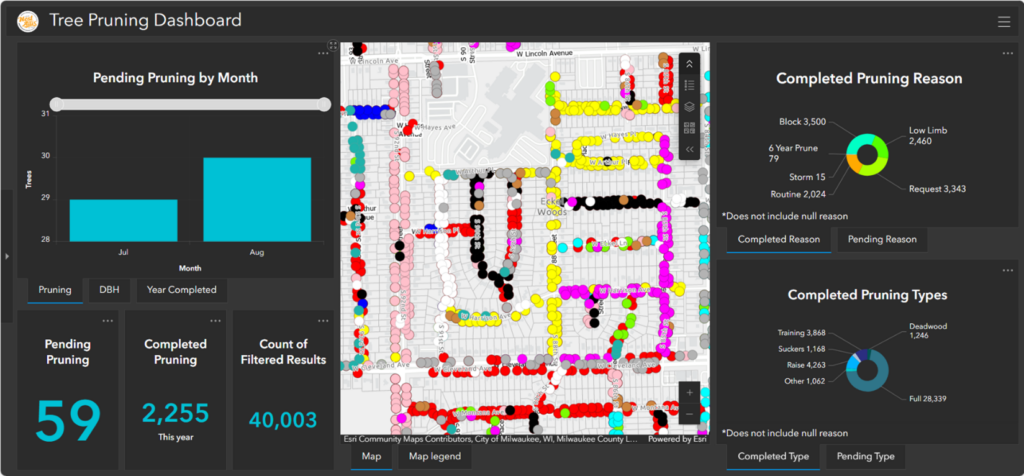
A dashboard hosted on ArcGIS Online showing trees which had been pruned in West Allis.
Each of the nine full-time arborists in West Allis has an iPad with a cellular data plan, as do two managers. When conducting tree work, staff access an AGOL application on the tablets called Field Maps, which is used to see and collect geographic data. That’s where the magic happens. Every time one of their 23,400 trees is visited, staff are expected to update the diameter, health condition and maintenance records of that tree. The data is entered in Field Maps and is immediately synced with the AGOL database. Though staff say it’s not perfect, it is an astoundingly up-to-date inventory.
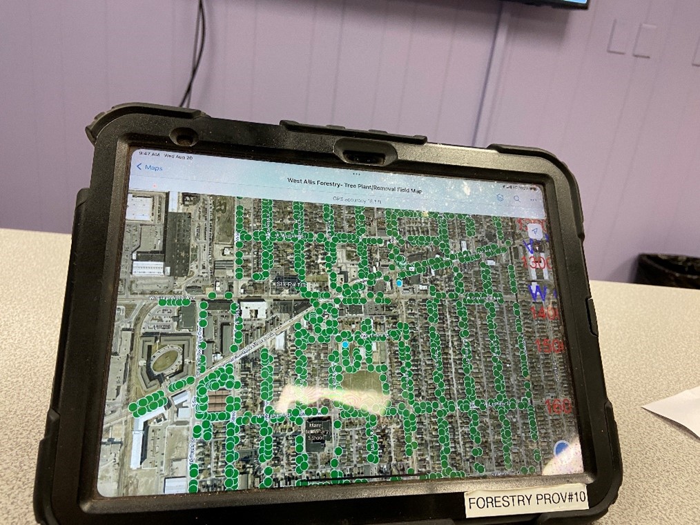
An i-Pad with Field Maps in use, an application within ArcGIS Online.
Because of the rich data collection tradition of West Allis Forestry, and the relatively user-friendly Field Maps application, the new inventory management process wasn’t particularly difficult for forestry staff to learn. However, it was important for managers to emphasize that when any work was done, it needed to be documented because documented work might trigger another work order (e.g., a removal would trigger a stump grinding order).
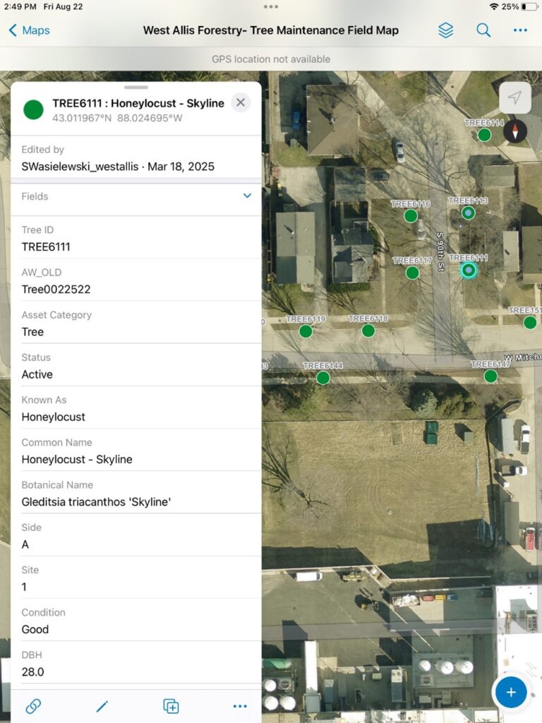
Data being edited within Field Maps by arborists in the field include diameter and health condition ratings.
Because the data are both accurate and live, managers can easily look at the city’s trees and planting sites on a map to make short-term decisions about daily maintenance needs and long-term decisions about where and what to plant in order to have a diverse, sustainable urban forest. Managers can also use these data to report to decision makers.
According to the city, the price tag on ArcGIS accounts, tablets and cellular connections is high, which may be prohibitive for smaller or resource-constrained communities. Luckily, there are other great GIS options to use, such as out-of-the-box (but still customizable) tree inventory software. Though West Allis has a fantastic inventory system (and, critically, a GIS administrator), it only works because of practices and procedures adopted by the Forestry Division early on. Other communities can adopt some of these less-costly methods such as using smartphones or tablets in the field, updating data every time a tree is touched and employing mapping programs to target trees needing work. More information about tree inventory options can be found on the DNR Urban Forestry website.
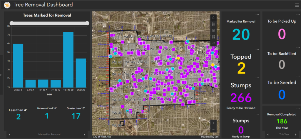
A dashboard hosted on ArcGIS Online showing trees marked for removal and stumps that ultimately need to be ground after notifying Digger’s Hotline.
The city’s shift to a robust, GIS-based inventory with field data entry has been a game-changer.
“It just made life easier,” said the city forester, Troy Heiman.
If you want to discuss inventory management ideas for your community, please reach out to your urban forestry coordinator or the DNR’s urban forestry assessment specialist, Dan Buckler.