
By Dan Buckler, Urban Forest Assessment Specialist, DNR
Whether you see urban trees as art, infrastructure or the lungs of your community, they are important assets in our state. And recently released tree canopy data from the DNR’s Urban Forestry program shows exactly where those trees and other woody vegetation exist in the state’s municipalities and urban areas.
The data shows how much each community is covered by tree canopy, non-woody vegetation, impervious surfaces (like concrete or rooftops), wetlands and water. This data could be used to gauge the extent of communities’ forest resources, set goals for future tree cover and identify priority areas for tree planting.
Canopy data is also used to calculate the ecosystem services (or “ecobenefits”) of the urban forest using i-Tree Landscape. Ecosystem services are those non-timber functions of trees which produce measurable benefits related to human health, and private and public infrastructure.
A land cover table and interactive map for all municipalities, urban areas and counties can be easily accessed. Raw GIS data is also available for download.
The aim of the Urban Tree Canopy analysis is to help decision makers understand their current and future urban forest resources. The urban tree canopy is one of a variety of datasets to help assess and raise awareness across the state about the diversity, age, size, health, utility and extent of urban forests.
The land classification was performed by the UW-Madison Department of Forest & Wildlife Ecology, Townsend Lab, under contract with the Department of Natural Resources. It was derived from aerial imagery captured under the National Agriculture Imagery Program in 2013. New assessments will be conducted in the future, enabling change detection in tree canopy over time.
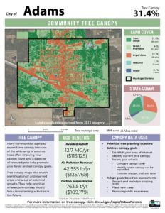
Summary datasheets featuring a map, land cover statistics and canopy information are available for each Wisconsin municipality upon request. Questions about canopy data, or requests for community datasheets, can be sent to DNRUrbanForestryAssessment@wisconsin.gov.