
Dan Buckler, Urban Forestry Assessment Specialist, Daniel.Buckler@wisconsin.gov
Trees are sometimes called the lungs of the Earth. You might also call them and the neighborly Lake Michigan the air conditioners of Milwaukee.
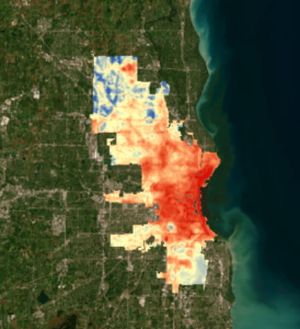
A preview of the Milwaukee Heat Map
The Wisconsin Department of Natural Resources helped coordinate a heat mapping campaign in the City of Milwaukee in 2022. A resulting map shows where it is relatively hot or cool.
Trees provide shade and conduct evapotranspiration, the process by which water moves from the ground, through their stems, and out their leaves as water vapor. In these ways, trees helped make parks and other green spaces temperature oases, with evening air temperatures up to seven degrees cooler than nearby locations.
Densely developed urban areas tend to be warmer than more open rural spaces due to the concentration of manmade surfaces, such as asphalt and concrete, that absorb and reradiate heat. This phenomenon, known as the urban heat island effect, is further compounded by rising temperature trends due to climate change.
Urban neighborhoods are also affected by this heat island dynamic, particularly in large cities such as Milwaukee, where there is a great variety of land covers and uses. The mapping campaign recorded a 10-degree difference in the evening between the hottest and coolest parts of the city.
The project produced maps of air temperature and heat index, showing what people experience throughout their day, no matter their neighborhood. This data will be integrated into decision-making processes, such as prioritizing where trees or cooling centers could have the most impact. Reducing local air temperatures could have a significant health effect on those who live, work and recreate in Milwaukee.
A simple interactive map of the temperature data is hosted by the DNR, as is a project report. Groundwork Milwaukee’s Climate Safe Neighborhoods dashboard includes temperature and humidity maps. Raw GIS data is also hosted by the DNR. Additional resources related to climate change and urban trees can be found here.