
By Dan Buckler, DNR Urban Forest Assessment Specialist
Daniel.Buckler@wisconsin.gov or 608-445-4578
The thought of increasing a community’s tree canopy cover is sometimes overwhelming given how many landowners are present. Think about all the stakeholders who have to buy into the initiative, not only with enthusiasm, but likely contributing money and time as well.
Contrast that with a more actionable approach focused on areas where there’s a single landowner or manager.
This was the route taken by graduate student Michelle Hess in a recent paper for a UW-Milwaukee Geography course. Michelle investigated tree canopy on Milwaukee Public Schools (MPS) properties to identify which schools should be prioritized for future greening initiatives, like those organized through ReFlo. The goal was to use canopy data provided by the DNR, identify which schools had lower canopy cover, merge those data with median household income of the local Census tract and come up with a prioritized list of schools in need of tree planting.
The results across 125 campuses were sobering, with most schools having less than 10% canopy cover.
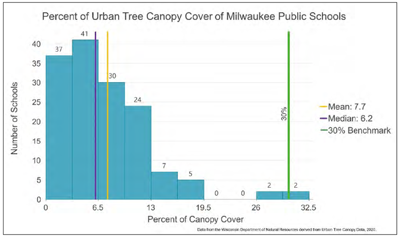
Chart by Michelle Hess.
Modeling lower canopied campuses with lower-income census tracts, Michelle identified 19 school campuses where tree planting should be prioritized. Focusing on these areas could have positive impacts not only on students’ test scores and mental health but also a myriad of other benefits for the surrounding neighborhoods.
Make no mistake: increasing canopy cover across a few, let alone all, MPS properties is a huge task. But it’s also more achievable and straightforward than, for example, increasing canopy cover across the entire city. That’s why I liked Michelle’s project — it’s actionable and a good use of tree canopy data.
We often say that limited resources should focus on retaining or planting trees where they are needed the most. Given the powerful impact of trees on young minds and hearts, school campuses can make a strong case for needing them most, particularly those highlighted by Michelle.
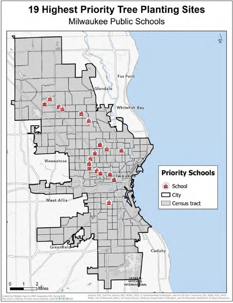
Map by Michelle Hess