By Wisconsin DNR
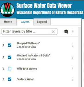
The Wisconsin Department of Natural Resources’ online Surface Water Data Viewer layers panel. / Graphic Credit: Wisconsin DNR
From recreation, to aesthetics, to ecosystem function and everything in between, there are many ways that water is an important aspect of owning and managing a property. It could be the showcase feature of a property such as lake frontage or a scenic river, or as subtle as a seasonal waterway or forested wetland.
Many landowners own woodlands because they want to enjoy the scenic beauty and protect nature and water. A first step toward achieving those goals is understanding what is present on the respective property. The Wisconsin Department of Natural Resources has a useful tool called the Surface Water Data Viewer (SWDV) to help landowners and land managers identify water resources.
Continue reading “Identify Water Resources With Surface Water Data Viewer”

 *These training opportunities are provided as an information service only and do not constitute an endorsement from the Wisconsin Department of Natural Resources (DNR).