
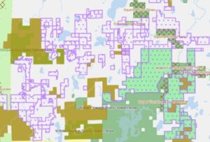
Updated private forest lands open for recreation layer showing the approximate area of enrolled lands. / Map Credit: Wisconsin DNR
By Wisconsin Department of Natural Resources
Managed Forest Land (MFL) and Forest Crop Land (FCL) open for public recreation have been updated in the DNR Public Access Land (PAL) mapping application to show the approximate on-the-ground area of these private forest lands open for recreation.
These areas are based on the MFL or FCL map, the tax parcel(s) and legal description(s) of the enrolled land. The features replace the point representation, which only identified the public land survey system (PLSS) quarter-quarter section of open MFL and FCL land. Users then had to download an MFL or FCL map to see the area of open land.
This update will allow users to see the approximate open MFL and FCL areas in relation to other basemap layers, such as roads, other public lands and tax parcels. The MFL and FCL maps are still available for download after selecting a specific property and viewing the detailed information for that enrollment.
Additionally, an access point layer has been created showing the access point and a description of the access for open MFL and FCL properties where access is not from an adjacent public road or other public land.
The MFL/FCL PAL help document has also been updated.
Questions or comments can be submitted through the PAL Help link available in the Terms of Use upon opening PAL, or by clicking the “Info” button in the lower right corner of the map.