
By Dan Buckler, DNR Urban Forest Assessment Specialist, Madison, daniel.buckler@wisconsin.gov or 608-445-4578
One needs only to look outside their window or at an aerial image to see that trees are not distributed evenly in their community. Of course, this is often expected and not indicative of any significant problem. One would expect, for example, for many parks to have more trees than densely developed parts of town.
However, sometimes uneven canopy distribution reveals something more harmful – that some neighborhoods and communities, often more wealthy ones, enjoy more canopy cover and thus more of the benefits trees provide. To help identify and mitigate this issue, American Forests recently released Tree Equity Score.
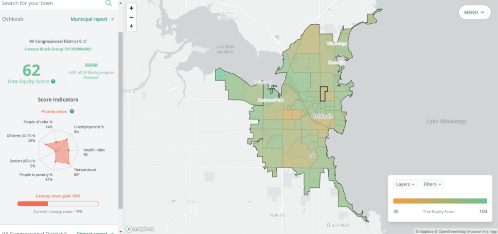
Figure 1 – an example of Tree Equity Score used in Oshkosh, WI. See the score along with demographic and environmental information on the left column.
The Tree Equity Score application is organized by neighborhoods (Census block groups), municipalities and counties. Each area’s equity score indicates how much less canopy the neighborhood has than it should and how prioritized it should be for tree planting based on different sociodemographic and environmental characteristics. The lower the score, the greater the priority for planting. So, for example, if a neighborhood has a low relative canopy cover and a high concentration of people living under the poverty line, that neighborhood would have a lower tree equity score.
More information is available on the webpage here.
The program also estimates the number of additional trees needed and potential ecosystem services produced if all neighborhoods in the community reach a certain tree equity score threshold.
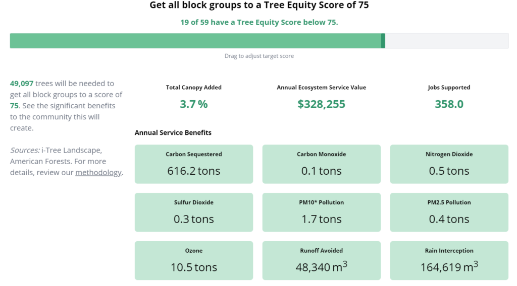
Figure 2 – a breakdown of what it would take for every neighborhood in Oshkosh to have a tree equity score of 75, along with the additional benefits those trees would offer.
Tree Equity Score is available for urbanized areas in the United States with over 50,000 people, excluding Puerto Rico. This amounts to 486 areas across the country, including 18 wholly or partially in Wisconsin. If you are part of one of the following metropolitan areas, the application could be useful:
Appleton, Beloit, Duluth/Superior, Eau Claire, Fond du Lac, Green Bay, Janesville, Kenosha, La Crosse, Madison, Milwaukee, Minneapolis–St. Paul, Oshkosh, Racine, Round Lake Beach–McHenry–Grayslake, Sheboygan, Wausau, West Bend
While the Tree Equity Score offers a new way of prioritizing tree planting locations, it might not be everything you want or need, or maybe you are outside of one of the above areas, or you need help interpreting results. If any of these is the case, do not hesitate to reach out, and we can navigate this world together – daniel.buckler@wisconsin.gov.