
By Catherine Koele, DNR Wildfire Prevention Specialist
It’s a fact – wildfires do happen in Wisconsin! Spring is wildfire season in the Great Lakes region, and the third week of April is designated Wildfire Prevention Week (April 17-23, 2022). Visit the DNR’s Wildfire Dashboard to view real-time and historic wildfires throughout the areas where the DNR has forest fire protection responsibility. They may happen more often and closer to your backyard than you think!
Every spring wildfire season is unique. Near the tail end of winter, wildfire professionals begin keeping a close eye on the snow depths, drought monitor, current and predicted weather patterns and, equally important, the fire occurrence and cause trends. In March of 2021, wildfire season began early as the snow rapidly melted statewide, with 204 fires burning 442 acres for the month. Fast forward to March of 2022 and notice a very different situation with 59 fires burning 120 acres for the same timeframe.
Despite the relatively slow start to this year’s fire season, fire occurrence is certainly starting to pick up. Historically, 60% of wildfires occur between March and May. Amid the busiest time for wildfires, take a closer look at emerging wildfires in DNR Protection areas* of Wisconsin, including acres burned, structure involvement, causes, weather conditions, fire behavior, resources assigned and much more on the wildfire view of the Fire Management Dashboards.
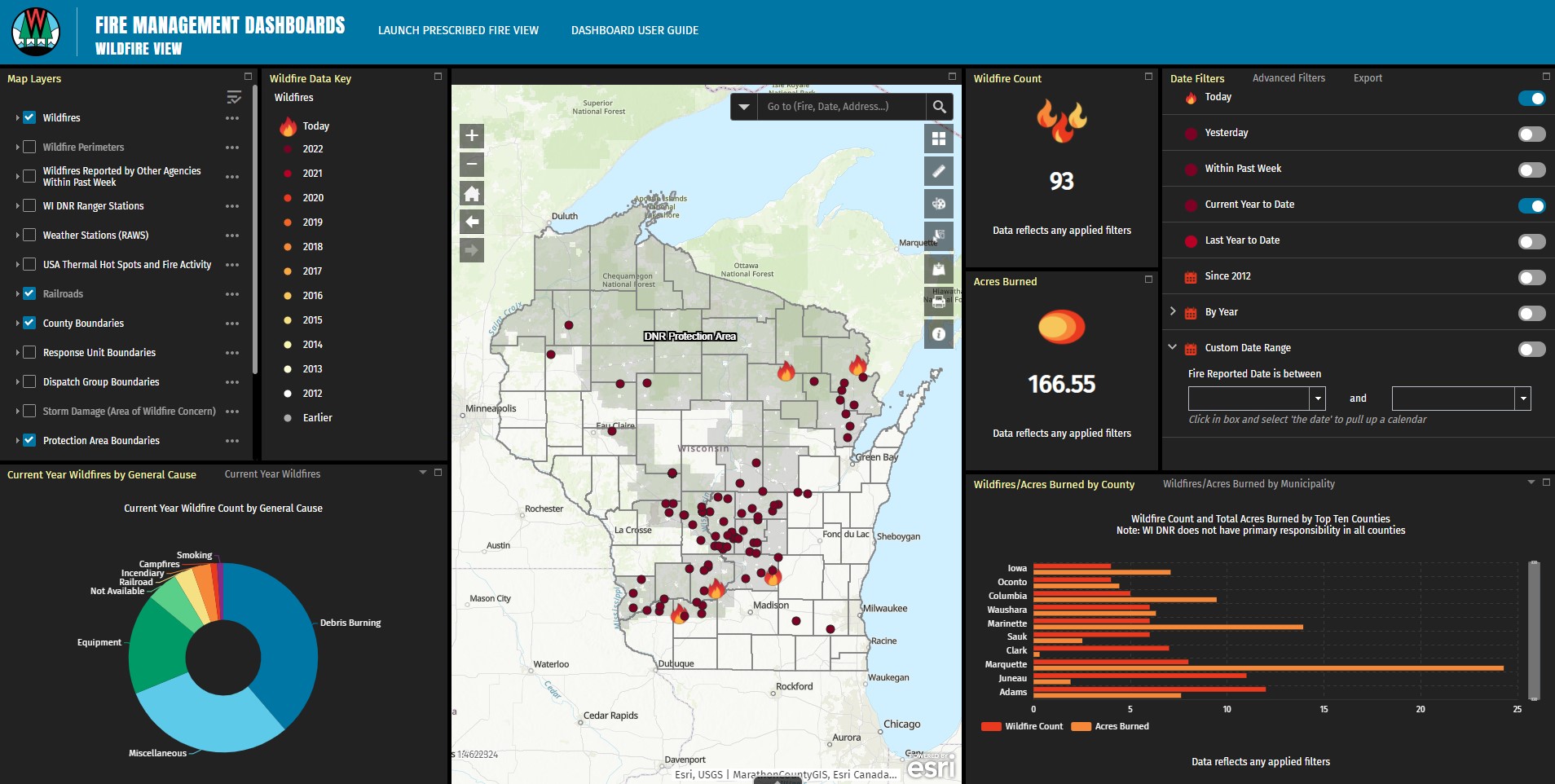
Search through ten years of historical wildfire data. Toggle between layers, zoom in on a geographic location or set some specific dates. A handy feature is the pre-set drop-down charts—users can apply numerous filters and watch the charts instantly do their magic.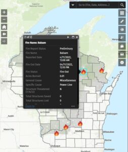
The dashboard is a “live” ArcGIS mapping application driven by data supported by Wisconsin’s Individual Forest Fire Reporting System. This diverse tool is an interactive visual representation of fire statistics that allows the user to select, query and export fire data for further analysis in formats compatible with other web mapping applications or ArcGIS Online (AGOL).
The mapping application also includes a Prescribed Fire Dashboard that shows occurring, planned and historic prescribed fires. Learn how applied fire molds into the DNR land and wildlife management goals and the various vegetation communities restored with applied fire use. Users can view the specifics of any prescribed burn conducted on DNR land, including the time frame, geographic area or other relevant filters.
Knowing and understanding the robust complexities, risks and benefits of the fire management program generates greater awareness of the ongoing mission to protect, enhance and sustain Wisconsin’s valuable resources. Visit this DNR webpage to use the Fire Management Dashboards.
*Areas outside the boundaries of DNR Protection areas are under the jurisdiction of the local municipality. Fire occurrence data will not be reflected in these cooperative areas on the dashboard unless a fire originates on state lands or the DNR provides mutual aid assistance.