By Dan Buckler, DNR Urban Forest Assessment Specialist
Daniel.Buckler@wisconsin.gov or 608-445-4578
Urban Tree Canopy (UTC) assessments using aerial or satellite imagery have been one of the primary ways people estimate the extent of urban forests across an area of interest, whether it be a single park, a streetscape or a whole community.
Two recently released UTC resources are ready for use by Wisconsin communities and urban forestry practitioners. The first, TreeCanopy.us, is a mapping application that shows UTC and other land cover in urban areas across the country for 2017 and 2022. It also shows changes in canopy cover between those five years.
The second resource is raw canopy and land cover GIS data hosted by the Wisconsin DNR for the years 2020 and 2022, also across urban areas of Wisconsin.

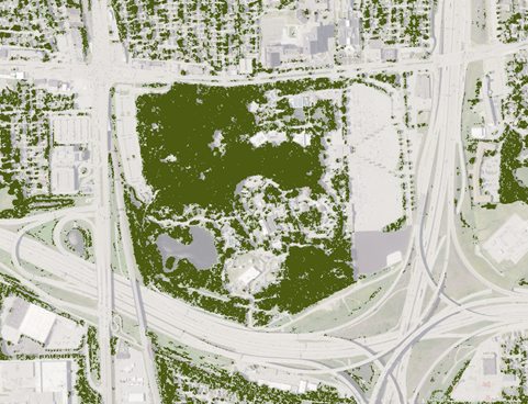
The tree canopy in and around Milwaukee County Zoo from the DNR’s 2020 dataset.
TreeCanopy.US
The new national dataset shows tree canopy and other land cover for the state’s urban areas, summarized at different geographic levels, including block groups (usually covering 600 to 3,000 people) and tracts (usually 1,200 to 8,000 people, but ideally 4,000). These are U.S. Census-defined geographic units that may or may not mean anything to you, but they are a way that populations are categorized across the country.
Importantly and uniquely, this national land cover map contains UTC for two different years – 2017 and 2022 – assessed with the same methodology. This has enabled an assessment of canopy change between those five years. For the first time, areas of canopy gain or loss can be identified for many locations. In addition to the map, summary data for those geographies (e.g., Census tracts) are available for download online.
There is currently no raw data available for customized analyses.
Wisconsin DNR Data
That’s where the Wisconsin DNR’s data comes in. There is a separate collection of GIS layers of tree canopy and land cover for 2020 and 2022 that can be downloaded from the DNR website. This is “raw” land cover data that can be used for customized analyses and queries. Do you want to identify the canopy cover of different parks that you manage? These data could get you there. You can download and use the data in-house or make a request to the DNR for assessments or analyses.
Note that this model was trained on trees, grass and impervious surfaces in highly developed spaces; the fields and wetlands that are sometimes on urban peripheries were not part of this study’s focus. Thus, there may be discrepancies between the model and reality in those types of spaces. Those items can be teased out for your custom requests.
What To Use, When
If you want a map to summarize canopy in urban areas or to understand canopy distribution, loss or gain across those places, TreeCanopy.us can be used. Within the application, users can pair the canopy data with other data to help identify priority or available planting places. For example, filtering the areas by a high amount of herbaceous (nonwoody) vegetation compared to trees could illustrate potential planting sites.
If you have canopy questions that require unique geographies (e.g., neighborhood boundaries or city parks), you likely cannot answer those with the national tool. However, the DNR data would be perfect for such queries. You can analyze the data yourself in-house, or you can make a request to the Urban Forestry program.
Cautions And Notes
Because of the variation between methodologies, it’s generally not recommended to directly compare estimates from one source to another; they are likely to be different. Similarly, there is significant variation in image quality and characteristics underlying most canopy estimates, and caution should be used in interpreting change. For example, the change shown in the new national tool is impressively accurate, though there are still relics related to differences in time, season or angle of the photography.

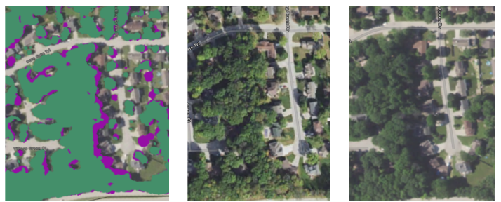
Snapshots from the national tool. On the left, purple is the 2017 canopy, and green is the 2022 canopy. It looks like the canopy was lost on the west side of the street, but that change is likely due to the radical differences in time and season when the imagery was taken. The 2017 image (middle) was taken on Oct. 1 at 10:30 a.m., while the 2022 image (right) was taken on June 22 at 4:15 p.m. Look at the changes in shadow and leaf color between those two years. Especially with those differences, it was quite a feat to compare these so well.
We will use this newsletter and other avenues to share analyses and additional canopy resources in the future. In the meantime, we are happy to help you navigate the different data sources and meet your needs. Please reach out to Dan Buckler at Daniel.Buckler@wisconsin.gov with your requests and questions.
