The Wisconsin Climate and Health Collaborative, a group of climate and health professionals from across the state working to create a healthier climate, people and communities through local action, wants to learn from you and your community! Take this short climate and health survey for a chance to win a Wisconsin state park pass. Responses are due April 15.
Data and analysis
The i-Tree Open Academy Returns In March 2024
Whether your work with trees involves planting, managing, funding, educating or beyond, i-Tree can help you better understand the benefits that trees provide, the impacts of where those benefits are and how to apply that science to your project goals.
The i-Tree Open Academy virtual learning series is back for spring 2024, with everything you need to explore the latest from the i-Tree suite of tools. Learn more and sign up on the i-Tree website. Continue reading “The i-Tree Open Academy Returns In March 2024”
New-And-Improved USDA Plant Hardiness Zone Map
The USDA Plant Hardiness Zone Map is the standard by which gardeners and growers can determine which perennial plants are most likely to thrive in a given location. The map is based on the average annual extreme minimum winter temperature, displayed as 10-degree Fahrenheit zones and 5-degree Fahrenheit half zones.
Thirty years of data was reviewed by a group of horticultural, botanical and climatological experts for the latest USDA Plant Hardiness Zone Map revision. This was determined to be the best balance between the fluctuations of year-to-year weather variation and the concept that, during their lifetimes, perennial plants mostly experience what is termed “weather” rather than “climate.” A complex algorithm was used for this edition of the Plant Hardiness Zone Map to enable more accurate interpolation between weather reporting stations. This method accounts for factors such as elevation change and proximity to bodies of water, making mapping zones more accurate. Continue reading “New-And-Improved USDA Plant Hardiness Zone Map”
Please Submit Trees Planted This Year
By Dan Buckler, DNR Urban Forest Assessment Specialist, Milwaukee, Daniel.Buckler@wisconsin.gov or 608-445-4578
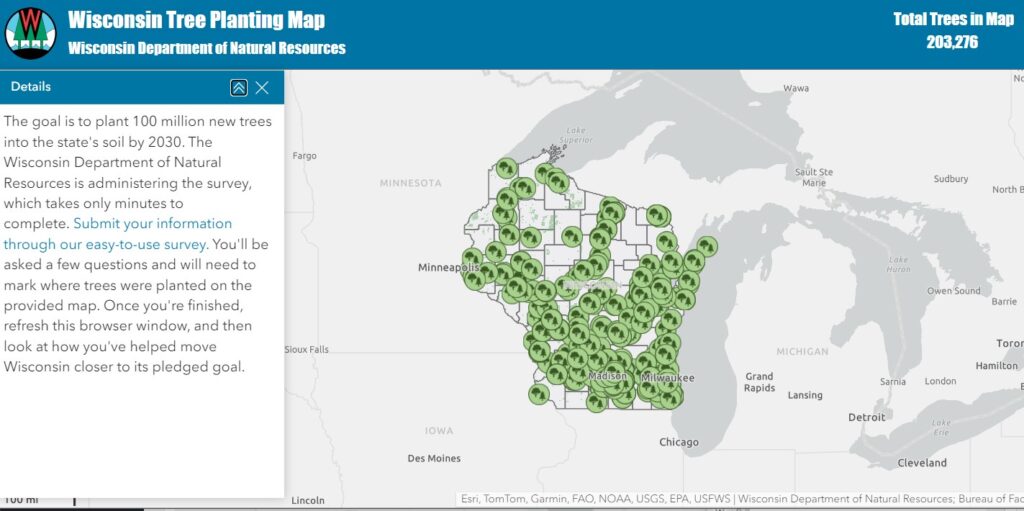
Autumn is a great time to plant trees. After the trees go in the ground, please take a few minutes to document the effort in the Wisconsin Tree Planting Map. The map was designed to help track trees planted to advance the state’s pledge to the Trillion Trees Initiative.
While the DNR may be able to track the ultimate destination of seedlings grown at the state nursery, or trees which have been funded by DNR grants, there are so many others planted across Wisconsin which go undocumented. The planting map was designed to help fill that void and to ensure that those trees are accounted for in our tallies.
Whether it was a planting of one tree or a thousand, take a couple minutes to submit your information through an easy-to-use survey.
The Good, The Bad And The Ugly: The Current State Of Public Trees In Southeastern Wisconsin
By Elton Rogers, Milwaukee Area Technical College and Dan Buckler, DNR Urban Forest Assessment Specialist, Milwaukee, Daniel.Buckler@wisconsin.gov or 608-445-4578
An urban forest is not an island. Trees and maintenance practices in one community inevitably affect the environment in another, while pests, pathogens and other damage agents don’t respect political boundaries. Because of these shared experiences, researchers have partnered with the Wisconsin DNR to assess the current state of publicly managed trees across the Milwaukee Metropolitan Area. Inventories from 40 organizations (mostly municipalities) totaling almost 440,000 trees point to worrying diversity issues and vulnerability to climate change, but also positive planting trends.
An article in the September issue of Arboriculture & Urban Forestry, the research publication of the International Society of Arboriculture, reviews the Milwaukee area’s species diversity, resilience to climate projections, availability of planting sites and more. A high-level summary of those results is below.
Free Data Collection Applications For Tree Inventories
By Dan Buckler, DNR Urban Forest Assessment Specialist, Milwaukee, Daniel.Buckler@wisconsin.gov or 608-445-4578
Tree inventories seem like such simple enterprises. Their purpose, essentially, is to determine what trees are growing where, in what shape they’re in and how big they are.
But to do them well requires expertise in arboriculture, proficiency with data collection and familiarity with GIS. And, of course, time. This is why many organizations turn to consulting arborists and foresters to conduct inventories and write management plans – they have that expertise and experience to see those projects through.
However, for some smaller or specialty projects, an organization may decide to collect tree data itself. For these efforts, a list of free digital data collection applications is available on the DNR website.
Continue reading “Free Data Collection Applications For Tree Inventories”
One Million Trees Now In Wisconsin Community Tree Map
By Dan Buckler, DNR Urban Forest Assessment Specialist, Milwaukee, Daniel.Buckler@wisconsin.gov or 608-445-4578
Ever since it launched in 2017, the Wisconsin Community Tree Map has been building a collective inventory of urban trees across the state. Now a milestone has been passed: over one million trees are in the database, giving users an expansive look at much of our urban forest.
Visitors to the tree map, a compilation of tree inventories from over 200 organizations, can use the tool to learn more about their local trees, such as species composition, size distribution, or even some of the ecosystem services those trees provide. Users can filter by certain attributes or areas to further identify trees of interest. Overall, it can be a powerful management, scientific, marketing and educational tool.
Continue reading “One Million Trees Now In Wisconsin Community Tree Map”
Updated Tree Inventory Requirements
By Dan Buckler, DNR Urban Forest Assessment Specialist, Milwaukee, Daniel.Buckler@wisconsin.gov or 608-445-4578
Tree inventories are foundational elements of sustainable urban forestry programs. You need to know what you have to best manage your trees. Because of the importance of these datasets, the Wisconsin DNR Urban Forestry program often funds inventories through their annual grants (open now through Oct. 2).
For the last few years, the program has required grant recipients that pursue inventories to collect a minimum baseline of attributes. These attributes ensure that the inventory is both useful to the organization and can be compiled into the Wisconsin Community Tree Map, a collection of tree inventories from around the state.
Heat Mapping Results From Milwaukee Published
Dan Buckler, Urban Forestry Assessment Specialist, Daniel.Buckler@wisconsin.gov
Trees are sometimes called the lungs of the Earth. You might also call them and the neighborly Lake Michigan the air conditioners of Milwaukee.
The Wisconsin Department of Natural Resources helped coordinate a heat mapping campaign in the City of Milwaukee in 2022. A resulting map shows where it is relatively hot or cool.
Trees provide shade and conduct evapotranspiration, the process by which water moves from the ground, through their stems, and out their leaves as water vapor. In these ways, trees helped make parks and other green spaces temperature oases, with evening air temperatures up to seven degrees cooler than nearby locations.
Densely developed urban areas tend to be warmer than more open rural spaces due to the concentration of manmade surfaces, such as asphalt and concrete, that absorb and reradiate heat. This phenomenon, known as the urban heat island effect, is further compounded by rising temperature trends due to climate change.
Urban neighborhoods are also affected by this heat island dynamic, particularly in large cities such as Milwaukee, where there is a great variety of land covers and uses. The mapping campaign recorded a 10-degree difference in the evening between the hottest and coolest parts of the city. Continue reading “Heat Mapping Results From Milwaukee Published”
What Do You Do With Your Old Christmas Trees?
By Dan Buckler, DNR Urban Forest Assessment Specialist, Daniel.Buckler@wisconsin.gov, 608-445-4578
At probably the same stage of life when I thought bread was just a medium to consume peanut butter, I thought the purpose of Christmas trees was to be a home for presents. However, like many people over the years, my appreciation for these incredible evergreen plants has grown. I love bringing green things into the home when the world can otherwise look bleak.
Unlike urban trees, which were planted and maintained for all sorts of benefits to humans and the wider environment, Christmas trees and other holiday plants are predominantly planted to be harvested at a young age. But like urban trees, their fate following their life’s work is unknown.
We wonder what you do with your Christmas trees or other holiday plants. We encourage you to fill out the short survey linked below. We are particularly interested in any novel ways you may utilize the plants. Next month, we will share results and, hopefully, a few stories.
SURVEY LINK Continue reading “What Do You Do With Your Old Christmas Trees?”