By Dan Buckler, DNR urban forest assessment specialist, Madison, daniel.buckler@wisconsin.gov, 608-445-4578
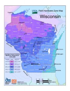
 Jack Frost descends upon us all in Wisconsin, but the depths to which he brings the mercury differ depending on your latitude, elevation, and proximity to water or urban areas. These differences are observed in a location’s cold hardiness zone, which represents the average minimum temperature a location is expected to experience.
Cold hardiness zones are well-known decision-making factors for anybody with a smidge of green on their thumb. But did you know that there are multiple hardiness zone maps out there, and that where you stand right now might be in zone 6 on one map, but zone 5 on another? Enter the labyrinth, dear reader.

 After a long and fruitful career with the Wisconsin DNR, Brad Johnson’s last day in the office was September 4, 2020. He started his DNR career as an integrated forestry team leader for Douglas County from 1993 to 2002 and transferred to the same position for Barron and Washburn County from 2002-2017. Since 2017, he has served as an Urban and Community Forestry Coordinator covering 19 counties along the west side of the state from the Spooner Ranger Station.
 1000 Friends of Wisconsin was awarded a U.S. Forest Service Great Lakes Restoration Initiative (GLRI) grant to plant 350 trees across four Green Tier Legacy Communities (GTLC) in 2018. The GLRI grant program, through USFS, intends to improve Great Lakes water quality by restoring, protecting, and maintaining Great Lakes ecosystems. 1000 Friends partnered with four GTLC’s Ashland, Bayside, Oshkosh and Sheboygan and the Wisconsin DNR Urban Forests Program.
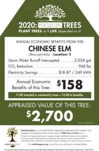
 “We have 6,715 street trees as of July 2020,” reported Kevin Westphal, Cedarburg Forester. “Totaling 70,000 diameter inches, the appraised value of Cedarburg’s street trees, based on CPI, is $10.5 million,” he continued.
  Wisconsin Arborist Association presents the 2020 Summer/Fall Seminar, seen directly from your home or office, for six days (two days per week for three weeks) between September 29 – October 15, 2020.
 Cities, villages, towns, counties, tribes and 501(c)(3) nonprofit organizations in, or conducting their project in, Wisconsin are encouraged to apply for a regular or startup 2021 Department of Natural Resources Urban Forestry Grant! The grants range from $1,000 to $25,000, and grant recipients must match each grant dollar for dollar. A startup grant of up to $5,000 is available for communities that want to start or restart a community forestry program. Grants are awarded to projects that align with state and national goals for increasing the urban forest canopy and the benefits it provides. Also available this grant cycle is an additional $175,000 in federal funding to be used for ash tree removals and replacements. EAB treatment will not be funded with these additional monies. Applications can be submitted starting July 1, 2020 until October 1, 2020.