By Bill McNee, DNR Forest Health Specialist, Oshkosh
Bill.McNee@wisconsin.gov
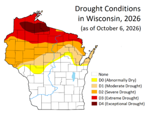
A Wisconsin map showing drought conditions as of October 6, 2026. Map created by David Mocko, NASA/GSFC/SSAI. / Graphic Credit: Wisconsin DNR
Property owners and land managers in the northern half of Wisconsin are encouraged to monitor forest stands and ornamental trees for signs of decline and mortality due to the intensity of the current drought. In late September, parts of several counties reached the “Exceptional Drought” condition on the U.S. Drought Monitor (see maps). This is the most severe drought category used and it has only been seen in Wisconsin one other time since the U.S. Drought Monitor was created in 1999 (source: National Weather Service).
Continue reading “Parts Of Northern Wisconsin Experience “Exceptional Drought” Conditions”