
By Dan Buckler, DNR Urban Forest Assessment Specialist
Daniel.Buckler@wisconsin.gov or 608-445-4578
One of the many challenges for urban foresters in navigating climate change is the fact that while temperatures are elevated across every season, it can still get pretty cold in Wisconsin, even along Lake Michigan. Nonetheless, hardiness zones are shifting, and there is plentiful experimentation underway by Wisconsinites to identify which tree species are appropriate for their location throughout the 21st century.
The Northern Institute of Applied Climate Science produced species vulnerability lists for six locations in Wisconsin, projecting what species are likely at increased risk (i.e. more vulnerable) under different climate change scenarios. Those are great resources that use the same background methodology as a species vulnerability analysis done for the Milwaukee metropolitan area.
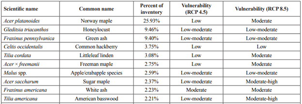
Vulnerability scores for the 10 most-planted species across the Milwaukee metropolitan area, from Rogers et al. (2023).
Additionally, to see what species have been working well in Wisconsin, you can access the Wisconsin Community Tree Map, a compilation of tree inventories that now contains over 1.2 million trees, mostly along streets. There, you can take advantage of the experimentation urban foresters have pursued from Kenosha to Superior and many places in between. It’s a relatively simple check you can make to see if communities in similar environments as yours have successfully grown certain species.
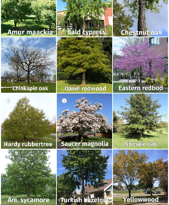
A few years ago, the Wisconsin Department of Natural Resources (DNR) produced an urban forestry story map that included a dozen generally underutilized species expected to grow moderately well across the state under different climate scenarios and are already present in some communities. These are by no means the only trees expected to do okay but were included in the story map to illustrate potential.
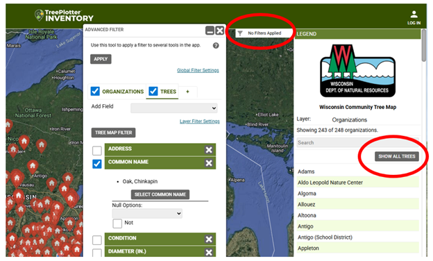
So, if you’re curious about how well a tree could do in Wisconsin, go to the tree map, click “Show All Trees” on the right side and then use the filter button to search for that particular species. It may also be useful to display by diameter size, too, to get a sense as to whether any of the trees have made it to a more mature age, demonstrating longevity on the landscape.
What we don’t know within the map, however, is the origin of the tree stock. Some individual trees may have relatively local genetics, though that information is ultimately unknown within the dataset. Some species have vast native ranges and origins in one part of those ranges may not bear as successful trees in Wisconsin as those with more local roots.